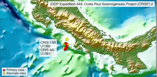
Map shows locations of other drilling sites in which a previous expedition worked. The Costa Rica Seismogenesis Project expeditions drilled holes identified as U1380 and U1381 in April 2011. |
Integrated
Ocean Drilling Program graphic
|
| International drill ship
again seeking
answers at Pacific plate |
|
|
By
the A.M. Costa Rica staff
A research vessel is again off the Costa Rican coast in the Pacific trying to learn more about the Cocos tectonic plate and earthquakes. The ship is the JOIDES Resolution, a drill boat designed to collect samples from under the ocean floor. The most recent visit began Oct. 23 and will last until Dec. 11. The research vessel was offshore previously from March 15 to April 13, 2011, and April 16 to June 3, 2011. The offshore area is attractive to scientists because this is where the Cocos tectonic plate is pushing under the lighter Caribbean plate. That is the reason the Pacific coast has so many earthquakes, including a 7.6 magnitude one last Sept. 5. The Resolution is named for HMS Resolution, commanded by Captain James Cook over 200 years ago, which explored the Pacific Ocean, its islands, and the Antarctic region, said the Integrated Ocean Drilling Program, which conducts the research. The boat has been in service since 1985. During the 47-day expedition, the Resolution scientists will try to understand how and when the Cocos plate started pushing under the Caribbean Plate, which holds Guatemala, Honduras, El Salvador, Nicaragua, Costa Rica, and Panamá, said the researchers. The Costa Rica Seismogenesis Project Expedition will try to find out what is happening with these plates as they push under each other along the area called the Costa Rica Subduction Zone, it said. This expedition will continue where the first expedition left off April 13, 2011, it added The researcher also seeks to determine when some of the |
volcanos in Central America
formed
and when some stopped erupting, said a summary. It added: "About 5 million years ago, the subduction of the Cocos Plate under the Caribbean Plate caused the volcanic land bridge to start forming between North America and South America. 68 volcanoes, many still active, are included in this chain. When this land bridge formed, the climate of the entire planet was affected. The Atlantic Ocean and the Pacific Ocean were no longer connected, and the Gulf Stream started flowing north along the eastern side of North America. Animals and plants were now able to travel between the two continents, as well, introducing new species to both." The date in which the isthmus connected the two continents is still being debated in scientific circles, despite the estimate by the Resolution summary. Scientists from the Smithsonian Tropical Research Institute in Panamá were at a conference Sunday in which some argued 3 million and others argued 15 million years. Dena Rosenberger, education officer on the current expedition, explains on a blog posting that the nanofossil group on board was working hard to photograph and categorize tiny fossils in the core samples brought up by the drilling. She noted that scientists can get an idea of the date of a particular geological layer because the fossils are biomarkers that show the temperature of the sea water and other conditions when they were alive. The Resolution usually carries about 50 scientists and 65 crew members. The boat is expected to make a post call in Puntarenas during the course of the current expedition. |
.
No comments:
Post a Comment
Please do NOT leave a anonymous post if you desire a response and do not leave bogus/unrelated to Costa Rica spam responses (whereby creating REALLY BAD karma for yourself and those you love!!!)